


Hiking trails in Øyer municipality
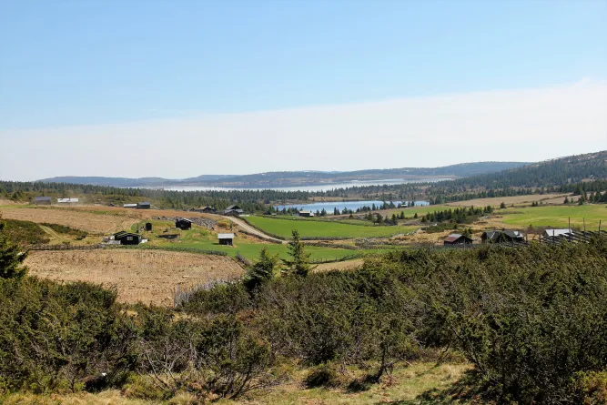
Øyer municipality has 18 hikes marked and signposted according to national standards to 10 viewpoints in Øyer and on Tretten. You will find both known and unknown trips, long and short, light and heavy, for young and old.
Øyer municipality has 18 hikes marked and signposted according to national standards to 10 viewpoints in Øyer and on Tretten. You will find both known and unknown trips, long and short, light and heavy, for young and old.
Maps and route descriptions can be downloaded and can also be found on ut.no. On the trips to the mountains, it is important to bring an ordinary map with you. Øyer Mountain Board has published an information map for Øyer state commons. The map is available for sale at shops and gas stations, and at the mountain board's office.
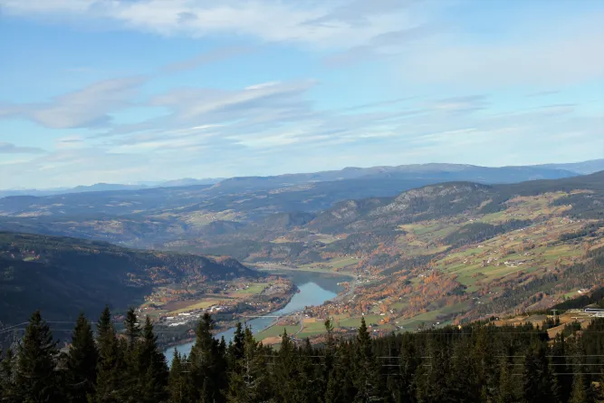
Stavsvegen at Tretten you follow the markings. The first part of the round goes on a flat easy forest path in spruce and pine forests. Eventually, the terrain rises steeply up to Flåtåmovegen. The route continues on a gentle incline on a good path up to the highest point of the round.
Take a detour to the viewpoint Lang berga. From Langberga there is a nice view of Tretten and the west side of Lågen. On the last part of the round, you can see the Fossum falls in the river Moksa. The hiking trail is marked in blue and signposted with a national standard.
From the information board at the intersection of Tuterud vegen / Stavsvegen at Tretten, follow the markings. The round takes you up Brattbakken and further on an old forest road in ascending terrain. Follow the forest road until Øvre Stavsrunden connects with Tuterudrunden. Take a detour to the Langberga viewpoint. Significantly easier round than the Tuterud round. The hiking trail is marked in blue and signposted with a national standard.
The Stake Promenade starts at Stavsgutua on Tretten and goes around the entire Stavsplassen. Walk along the Moksa River on flat terrain until the path turns right. You pass the campsite and can follow the signs to Bådstø or walk across Stavsplassen to the veterinary building. The last part of the round follows the Hippodrome and ends at the Equestrian statue Gjestar. The hiking trail is signposted with a national standard.
The hike up to the village castle at Vard kam pen follows the marked path through beautiful forest terrain. The trip is suitable for everyone. From the top of Vardkampen, you have a fantastic view of Tretten in the north, Øyer in the south and Musdal in the northwest. Return the same way down. Vardkampen is one of approx. 400 registered rural castles in Norway. The facility may have been a castle or a refuge for those who lived in the area. East of the summit, about 160 meters steep down, is Tjodvegen, which was an important thoroughfare through Gudbrandsdalen. The hiking trail is marked in blue and signposted with a national standard
From Rustberg camping, follow the marked path towards Høgberget. Take the detour to the viewpoint. Great view of Øyer! Return the same road and follow the path further west towards Skarsmoen. You should definitely take the trip up to the Tverrberget viewpoint as well. Pay attention to the marking there. The path up to Tverrberget is somewhat demanding, but ropes have been laid out
as support. After the visit to Tverrberget, you walk the same way back, and follow the forest road down to Skarsmoen farm. Follow the marked path through the yard and continue east back to Rustberg camping. The hiking trail is marked in blue and signposted with a national standard.
The beach promenade runs in easy terrain between the bridge over Lågen at Tingberg in the south and Rustberg Camping in the north. About halfway is Odden Camping. You follow the same route both ways. Parts of the promenade can be flooded at times when Lågen has a high water flow. A bit south of Odden Camping, you pass two large rocks that lie between the promenade and the E6. The furthest south is called the "Gesell stone" and was used as a resting and resting place for wandering finds, or journeymen as they were called.
A couple of hundred meters further north, there is a large stone on a pedestal with an inscription showing the water level in Lågen during the major floods of 1860 and 1938. In exchange for a fishing license, you can try your luck at fishing on the stretch. The hiking trail is signposted with a national standard.
From Sølvskottberget you follow the old farm road that has been in use since the 1600s. After approx. 0.6 km, turn off the mountain farm road and follow the signs to Utsikten. The trip is on dry ground in light forest terrain. The view is located on a hill with a great view of large parts of Øyerbygda. Be aware that there may be some steep slopes in the area. Return goes along the same path. The hiking trail is marked in blue and signposted with a national standard.
From Sølvskottberget you follow the old farm road that has been in use since the 1600s. After approx. 1 km you will enter a forest road that you follow to Skjønsbergaksla. The trip takes place on dry ground in varied forest terrain. At Skjønsbergaksla there is a simple shelter and fantastic views of the entire Øyerbygda. NB! Skjønsbergaksla is located on the edge of a high cliff. Return goes along the same route. The hiking trail is marked m.
From Sølvskottberget, large parts of the trip follow the old farm road that has been in use since the 1600s. The trail runs on dry ground in varied forest terrain, but after approx. 2 km you pass a marsh where the ground is wet. Along the route, you pass Hundbergetseter, where it is nice to take a break. Up towards the top of Hundbergslia there is some climb. At the top
of Hundbergslia there is a great panoramic view of the village, into Øyerfjellet, towards Jotunheimen and Rondane. After your visit to Hundbergslia, you can walk around Nordbygdsmorka. The hiking trail is marked in blue and signposted with a national standard.
Park on Sølvskottberget. Follow the old farm road approx. 1 km towards Hundberget. You are then inside Nordbygdsmorka rundt. The round goes in varied forest terrain, along paths, old farm roads and forest roads. The round goes mainly on dry ground, but route one crosses a marsh where there is some wet terrain. Along the round, you pass the old farms Smørkampsætra and Hundberget, as well as the small farm Veslestulen. At Hundberget it is nice to take a break. The hiking trail is marked in blue and signposted with a national standard
The hiking trail around Haugen starts above Nermo hotel in Øyer. After following the marked path up approx. 900 m, you will come to a nice viewpoint. From the viewpoint you follow the gravel road up to Haugen with the old farm house from the 1730s. Immediately afterwards, you follow Hankevegen into the valley, and after a couple of hundred meters you take the path steeply downhill
towards Mosåa and over the footbridge. The hiking trail continues past Berge and Søndre Lyseng, and crosses the Mo sæter road before Lilletorvet. The area where the saw is now located has always had the name Lilletorvet because it was an old gathering point for people in the hamlet. Once down on Sørbygdsvegen, you follow the pedestrian road north towards the starting point above Nermo hotel. The hiking trail is marked in blue and signposted with a national standard.
From the junction above Nermo hotel in Øyer, follow the pilgrim path north. The pilgrim path follows the old village road to Lisgrenda. After you have passed Jutulstad, which is located on the lower side of Lie-Hornsjøvegen, turn right up the old farm road to Haugen. Follow the markings. At the top of the long hill, turn right and follow the markings down towards Nermo again. The hiking trail is marked in blue and signposted with a national standard.
From the centre of Øyer, follow the pedestrian and cycle path northwards. The trip goes in varied terrain on varied surfaces. The trip goes through the forest at Storkjølla (large water source) and follows the Old Road south towards Korsen and the war memorial. From Korsen, follow the signs back to the center of Øyer. The hiking trail is signposted with a national standard.
From the center of Øyer, follow the signs to Aronsvestranda. The hiking trail is universally designed. From county road 319, the hike follows the Fiske hus road before the hiking trail goes through a wooded area. The tour continues south through the forest and passes a bomb crater from World War II (23.4.1940). The universal part of the trail stops at Aronsvestranda where you can take a break. Re touring the same way or continue on the forest path and through the pedestrian tunnel under the E6. On the east side of the E6, the path goes through the forest by the youth school before returning to the center of Øyer. In exchange for buying a fishing license, you can try your luck at fishing in Lågen. The hiking trail is signposted with a national standard.
The hiking trail starts on the west side of the river Lågen at Haugalykkja in Øyer. The trip is marked in blue and signposted with the national standard. The trip goes through Fakkelmannen in steep forest terrain and continues further up to Brånån. At the top, follow the marked path 300 m north to the viewpoint Brånån (668 m). From Brånån you have the village's best view of Øyerfjellet. NB! The Brånån viewpoint is located on the edge of a high cliff. Return the same way down, feel free to take a detour to Haugakampen.
Olympic and world champion in cross-country skiing, Erling Jevne, used this trip as training. His record is 17.54 min. Up!
The hiking trail starts on the west side of the river Lågen at Haugalykkja in Øyer. The trip is marked in blue and signposted with the national standard. The trip follows the route towards Brånån and goes in steep forest terrain. From the main trail, turn left towards Haugakampen (498 m.a.s.l.) where the view towards Hafjell and Sørbygda is phenomenal. NB! The viewpoint Haugakampen is located on the edge of a high cliff. Return the same way down
At the bottom of Musdal on Thirteen, two hiking trails start;
Måsåbergan and Vassrudmoen. Parking at the information board at Nedre Wasrud. Måsåbergan runs in varied spruce and pine forest over low-clad mountains to Høgberget with a view of Losna, Stav and Tretten center. Along the way, you will pass a climbing rock where little feet can unfold. Before Høgberget, there are several trees where the spotted woodpecker has attached pine cones to pick out seeds. Under the trees there are piles of pine cones. If you want a shorter trip, we recommend the hiking trail Vassrudmoen, which runs in almost flat terrain in pine forest. The trails are marked in blue and signposted with the national standard.
Maps and route descriptions can be downloaded and can also be found on ut.no. On the trips to the mountains, it is important to bring an ordinary map with you. Øyer Mountain Board has published an information map for Øyer state commons. The map is available for sale at shops and gas stations, and at the mountain board's office.
The Tuterud Round
Stavsvegen at Tretten you follow the markings. The first part of the round goes on a flat easy forest path in spruce and pine forests. Eventually, the terrain rises steeply up to Flåtåmovegen. The route continues on a gentle incline on a good path up to the highest point of the round.
Take a detour to the viewpoint Lang berga. From Langberga there is a nice view of Tretten and the west side of Lågen. On the last part of the round, you can see the Fossum falls in the river Moksa. The hiking trail is marked in blue and signposted with a national standard.
Øvre Stavsrunden
From the information board at the intersection of Tuterud vegen / Stavsvegen at Tretten, follow the markings. The round takes you up Brattbakken and further on an old forest road in ascending terrain. Follow the forest road until Øvre Stavsrunden connects with Tuterudrunden. Take a detour to the Langberga viewpoint. Significantly easier round than the Tuterud round. The hiking trail is marked in blue and signposted with a national standard.
The Stake Walk
The Stake Promenade starts at Stavsgutua on Tretten and goes around the entire Stavsplassen. Walk along the Moksa River on flat terrain until the path turns right. You pass the campsite and can follow the signs to Bådstø or walk across Stavsplassen to the veterinary building. The last part of the round follows the Hippodrome and ends at the Equestrian statue Gjestar. The hiking trail is signposted with a national standard.
Vårdkampen
The hike up to the village castle at Vard kam pen follows the marked path through beautiful forest terrain. The trip is suitable for everyone. From the top of Vardkampen, you have a fantastic view of Tretten in the north, Øyer in the south and Musdal in the northwest. Return the same way down. Vardkampen is one of approx. 400 registered rural castles in Norway. The facility may have been a castle or a refuge for those who lived in the area. East of the summit, about 160 meters steep down, is Tjodvegen, which was an important thoroughfare through Gudbrandsdalen. The hiking trail is marked in blue and signposted with a national standard
Skarsmoen
From Rustberg camping, follow the marked path towards Høgberget. Take the detour to the viewpoint. Great view of Øyer! Return the same road and follow the path further west towards Skarsmoen. You should definitely take the trip up to the Tverrberget viewpoint as well. Pay attention to the marking there. The path up to Tverrberget is somewhat demanding, but ropes have been laid out
as support. After the visit to Tverrberget, you walk the same way back, and follow the forest road down to Skarsmoen farm. Follow the marked path through the yard and continue east back to Rustberg camping. The hiking trail is marked in blue and signposted with a national standard.
Promenade
The beach promenade runs in easy terrain between the bridge over Lågen at Tingberg in the south and Rustberg Camping in the north. About halfway is Odden Camping. You follow the same route both ways. Parts of the promenade can be flooded at times when Lågen has a high water flow. A bit south of Odden Camping, you pass two large rocks that lie between the promenade and the E6. The furthest south is called the "Gesell stone" and was used as a resting and resting place for wandering finds, or journeymen as they were called.
A couple of hundred meters further north, there is a large stone on a pedestal with an inscription showing the water level in Lågen during the major floods of 1860 and 1938. In exchange for a fishing license, you can try your luck at fishing on the stretch. The hiking trail is signposted with a national standard.
The view
From Sølvskottberget you follow the old farm road that has been in use since the 1600s. After approx. 0.6 km, turn off the mountain farm road and follow the signs to Utsikten. The trip is on dry ground in light forest terrain. The view is located on a hill with a great view of large parts of Øyerbygda. Be aware that there may be some steep slopes in the area. Return goes along the same path. The hiking trail is marked in blue and signposted with a national standard.
Skjønsbergaksla
From Sølvskottberget you follow the old farm road that has been in use since the 1600s. After approx. 1 km you will enter a forest road that you follow to Skjønsbergaksla. The trip takes place on dry ground in varied forest terrain. At Skjønsbergaksla there is a simple shelter and fantastic views of the entire Øyerbygda. NB! Skjønsbergaksla is located on the edge of a high cliff. Return goes along the same route. The hiking trail is marked m.
Hundbergslia
From Sølvskottberget, large parts of the trip follow the old farm road that has been in use since the 1600s. The trail runs on dry ground in varied forest terrain, but after approx. 2 km you pass a marsh where the ground is wet. Along the route, you pass Hundbergetseter, where it is nice to take a break. Up towards the top of Hundbergslia there is some climb. At the top
of Hundbergslia there is a great panoramic view of the village, into Øyerfjellet, towards Jotunheimen and Rondane. After your visit to Hundbergslia, you can walk around Nordbygdsmorka. The hiking trail is marked in blue and signposted with a national standard.
Around Nordbygdsmorka
Park on Sølvskottberget. Follow the old farm road approx. 1 km towards Hundberget. You are then inside Nordbygdsmorka rundt. The round goes in varied forest terrain, along paths, old farm roads and forest roads. The round goes mainly on dry ground, but route one crosses a marsh where there is some wet terrain. Along the round, you pass the old farms Smørkampsætra and Hundberget, as well as the small farm Veslestulen. At Hundberget it is nice to take a break. The hiking trail is marked in blue and signposted with a national standard
The mound
The hiking trail around Haugen starts above Nermo hotel in Øyer. After following the marked path up approx. 900 m, you will come to a nice viewpoint. From the viewpoint you follow the gravel road up to Haugen with the old farm house from the 1730s. Immediately afterwards, you follow Hankevegen into the valley, and after a couple of hundred meters you take the path steeply downhill
towards Mosåa and over the footbridge. The hiking trail continues past Berge and Søndre Lyseng, and crosses the Mo sæter road before Lilletorvet. The area where the saw is now located has always had the name Lilletorvet because it was an old gathering point for people in the hamlet. Once down on Sørbygdsvegen, you follow the pedestrian road north towards the starting point above Nermo hotel. The hiking trail is marked in blue and signposted with a national standard.
Jutulstad
From the junction above Nermo hotel in Øyer, follow the pilgrim path north. The pilgrim path follows the old village road to Lisgrenda. After you have passed Jutulstad, which is located on the lower side of Lie-Hornsjøvegen, turn right up the old farm road to Haugen. Follow the markings. At the top of the long hill, turn right and follow the markings down towards Nermo again. The hiking trail is marked in blue and signposted with a national standard.
Storkjølla
From the centre of Øyer, follow the pedestrian and cycle path northwards. The trip goes in varied terrain on varied surfaces. The trip goes through the forest at Storkjølla (large water source) and follows the Old Road south towards Korsen and the war memorial. From Korsen, follow the signs back to the center of Øyer. The hiking trail is signposted with a national standard.
Aronsvestranda
From the center of Øyer, follow the signs to Aronsvestranda. The hiking trail is universally designed. From county road 319, the hike follows the Fiske hus road before the hiking trail goes through a wooded area. The tour continues south through the forest and passes a bomb crater from World War II (23.4.1940). The universal part of the trail stops at Aronsvestranda where you can take a break. Re touring the same way or continue on the forest path and through the pedestrian tunnel under the E6. On the east side of the E6, the path goes through the forest by the youth school before returning to the center of Øyer. In exchange for buying a fishing license, you can try your luck at fishing in Lågen. The hiking trail is signposted with a national standard.
Brånån
The hiking trail starts on the west side of the river Lågen at Haugalykkja in Øyer. The trip is marked in blue and signposted with the national standard. The trip goes through Fakkelmannen in steep forest terrain and continues further up to Brånån. At the top, follow the marked path 300 m north to the viewpoint Brånån (668 m). From Brånån you have the village's best view of Øyerfjellet. NB! The Brånån viewpoint is located on the edge of a high cliff. Return the same way down, feel free to take a detour to Haugakampen.
Olympic and world champion in cross-country skiing, Erling Jevne, used this trip as training. His record is 17.54 min. Up!
Haugakampen
The hiking trail starts on the west side of the river Lågen at Haugalykkja in Øyer. The trip is marked in blue and signposted with the national standard. The trip follows the route towards Brånån and goes in steep forest terrain. From the main trail, turn left towards Haugakampen (498 m.a.s.l.) where the view towards Hafjell and Sørbygda is phenomenal. NB! The viewpoint Haugakampen is located on the edge of a high cliff. Return the same way down
Måsåbergan
At the bottom of Musdal on Thirteen, two hiking trails start;
Måsåbergan and Vassrudmoen. Parking at the information board at Nedre Wasrud. Måsåbergan runs in varied spruce and pine forest over low-clad mountains to Høgberget with a view of Losna, Stav and Tretten center. Along the way, you will pass a climbing rock where little feet can unfold. Before Høgberget, there are several trees where the spotted woodpecker has attached pine cones to pick out seeds. Under the trees there are piles of pine cones. If you want a shorter trip, we recommend the hiking trail Vassrudmoen, which runs in almost flat terrain in pine forest. The trails are marked in blue and signposted with the national standard.
Read more
Contact information
- +47 61 26 81 00
- [email protected]
- Kongsvegen 325 - 2636 - Øyer